Space Debris – Visualizing the Risk and Informing Stakeholders

Everybody in a reasonably advanced society (and many of the not so advanced ones) uses products and services that are dependent on satellites and their specific capabilities, many of which cannot be substituted for on Earth. You may use satellite communications and weather prediction services, and sometimes you may use GPS (for transport, tourism and for tagging your friends on Facebook), but you are also consuming space services through intermediaries. Your Amazon order arrived safely, cheaply and on time through a GPS dependent global distribution service. The gadget you bought was the result of a globalized production chain kept viable by global communications, global transport and global finance. Your online payments, bank transactions and stock market investments are time stamped by atomic clocks located in GPS satellites. One day, you may even receive medical services or even have a robot perform surgery on you through telemedicine. And, in a crisis and emergency situation, space services such as Earth Observation are invaluable for decision makers and responders. The list goes on and on.
The Union of Concerned Scientists maintains an open source database of all satellites in Earth’s orbit, though the current numbers are just a fraction of the number of satellites launched throughout the last half century.

Fig. 1 – Breakdown of all known satellites in orbit, data collected by UCS[1]
Many countries have tried and managed to launch satellites for exploitation, science or simple prestige, as the following UCS chart shows, though the number of countries with actual launch capabilities is a lot smaller.
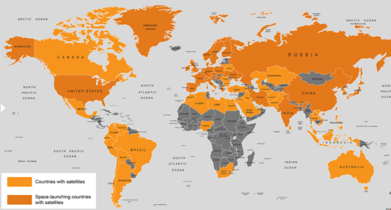
Fig. 2 – Map of countries which have launched satellites or have launch capabilities[2]
But these satellites are just as vulnerable to risks, vulnerabilities and threats as are the terrestrial systems on which we rely and which we term critical infrastructures. Some of the risks are common and very current, like cyber-attacks. Some are what we call HILF, high impact – low frequency events that nonetheless affect all kinds of systems – solar storms are an example that captures the imagination. Others are specific threats – the inherent harshness of the space environment, the threat of anti-satellite weaponry or the risk of space debris collision. This article focuses on the latter threat, a very real issue which affects an almost trillion-dollar industry on which we rely. It also describes a development in the field which may aid us in tackling this threat, by exposing it to the general public and to private stakeholders, not just the specialists at the European Space Agency and NASA, who are already well aware of the threat. Ultimately, this type of science diplomacy and outreach is both trend and tool for advanced societies.
Big business
The yearly State of the Satellite Industry report[3], released each September by the US Satellite Industry Association and compiled by the Bryce Company (formerly Tauri Group), shows just how developed the satellite service industry has become and how much of it is in private hands, operating under normal economic incentives, as opposed to the government run basic science missions that people normally envision in orbit. Large-scale private ownership is a reality also for terrestrial critical infrastructures, like power plants, ports, farms and other important assets, which will affect considerations regarding security governance and security resources.

Fig.3 – Member companies of the Satellite Industry Association in the US[4]
The 2016 report, which only covers private industry, not state activities, highlights that, in 2015, as in every year before that, the industry’s growth has outpaced global or US growth, reaching 208 billion dollars, almost twice what it was in 2006. The number of satellites which were launched stayed roughly the same as in 2014, being over 200, but this ignores the fact that the number doubled after 2013, due to large scale introduction of cubesats, very small satellites that are more affordable and can be launched in large groups, lowering the financial cost of access to space tremendously for marginal operators (universities, small countries etc.). 53% of satellites launched in 2015 were cubesats, and the area has significant potential for growth, in addition to the more financially and technologically intensive large satellite systems.

Fig.4 – Breakdown of revenue of the global satellite industry[5]
Trashing space
A lot of effort has been spent to raise public awareness about environmental issues on Earth, related to the persistence of trash, the harm to environment, the unsightliness and dangers of trash heaps and landfill. What if someone told you that humanity has the same problem in space, with the same serious consequences? Since nobody lives there on a permanent basis, you can describe the process as everybody leaving trash and waste from their picnic in a national park. And it has been piling up for over 60 years, since the first man-made object, Sputnik, launched into space. According to the European Space Agency, as of January 2017, the total mass of space debris in orbit is 7,500 tons, divided by size as follows[6]:
- 29 000 objects >10 cm;
- 750 000 objects − from 1 cm to 10 cm;
- 166 million objects − from 1 mm to 1 cm.

Fig. 5 – Simulation of orbital debris and other objects around Earth (Source: ESA) [7]
Unlike national territories and more akin to the open seas or air, space is an international environment. You cannot confine your pollution to the country that produced it, or to the space above it. It is actually nonsensical. Satellites orbit the Earth in the precise bands of space they require to perform their functions, whether it is to provide weather data, communications or TV signals. The most valuable bands are the most widely utilized, therefore accumulating the most trash. So, this is a collective issue. Even though only a few countries account for the vast bulk of space systems and accumulated trash, everybody benefits from the services themselves, sometimes critically.
Because of natural phenomena like gravity and air friction, some of the trash burns up in the Earth’s atmosphere, if it is in a low enough orbit. Otherwise, it persists for years, decades, even centuries, constituting a hazard to space ships, astronauts, space stations and, of course, active satellites. Out of the 42,000 tracked objects placed into orbit by 5,250 launches, 23,000 are still there, but only 1,200 are still active[8]. The debris stems from a few key sources, to the extent we can track them[9]:
- 42% - fragments from disintegrated space systems, especially satellite systems;
- 22% - whole, but non-functioning space systems;
- 19% - resulting from space mission specific activities;
- 17% - debris from the launchers placing satellites outside the atmosphere of Earth.
Of course, there is also naturally occurring debris, like dust, meteorites and so on. As for national origins, the extent of the contribution partly correlates with the role of the country in the space race – China – 40%; USA – 27.5%; the USSR/Russian Federation – 25.5%[10]. The apparent discrepancy between China and the two established space powers is due to two factors. The first is China’s late, but powerful, arrival in the space race, whereas the other two countries have produced much more debris in the long-term, but a lot of it has had enough time to be eliminated naturally, through atmospheric reentry, since most satellites are located in the very useful low Earth orbits (LEO). Approximately 49% of extant satellites are in LEO, 6% are in MEO (medium orbit), and 41% are in GEO (geosynchronous, where they always face the same part of Earth), the remainder being in elliptical and other orbits[11]. The former category permits the natural regeneration of the space environment, through atmospheric reentry of debris. The second factor is the very large effect that testing anti-satellite weaponry (ASAT) has on space debris[12]. In its 2007 FengYun-1C test, in which an inactive weather satellite was destroyed by China, the equivalent of 12% of the entire stock of orbital debris was created in one strike[13]. This was only the second kinetic ASAT test in history, after the inaugural one in 1983 performed by the Americans. The year after the Chinese test, in operation “Burnt Frost”, the Americans tested a new generation of ASAT weaponry[14]. This whole episode shows the destructive power of ASAT weaponry and the potential for escalation in space conflicts, with devastating global results, which is why the non-militarization of space, the non-proliferation of space weaponry and the control of their use is on the agenda for major global policy initiatives, like the Conference for Disarmament or various UN legislative projects in the field of space.

Fig. 6 – Evolution of debris number in space, breakdown by origin[15]
A single fleck of paint, travelling at orbital speeds, can destroy a satellite with a force that puts a high-powered bullet to shame. The International Space Stations regularly performs evasive maneuvers to avoid collisions with large pieces of debris though the photo below shows that even the smallest ones, which are harder to track and avoid, still pose incredible danger. NASA’s Space Surveillance System only tracks debris as large as 5 cm, whereas the 7-mm chip in an ISS viewport was caused by a piece a few thousandths of a millimeter large.

Fig. 7 – Mark left in ISS viewport by impact with very small debris[16].
Where possible, satellites also perform evasive maneuvers, but at the cost of their usable lifespan, since their limited supply of fuel for thrusters is required for station keeping, which is the maintenance of their position throughout their operational lifetime. Collisions are not just with tiny debris, but also with pieces of satellites or entire non-functioning satellites, as happened during the collision of telecommunications satellite Iridium 66 with an inactive Russian satellite, Cosmos 2251, in 2009. Even though space is, proverbially, very big, the most useful orbits are so crowded, that satellites routinely pass within proximity of each other at hypervelocity, while Iridium 66 and Cosmos 2251 were estimated to pass at around 500 m distance[17]. There is no current means of refueling and repairing satellites in space, though a few start-ups are working on solutions and NASA has, in the past, undertaken a risky manned mission to repair the irreplaceable Hubble telescope. The sort of treatment reserved for Hubble and the ISS is not available to other space assets, not if the industry is going to be financially sustainable.
The biggest threat when it comes to space debris is not just the potential for crippling or destroying satellites, or even endangering astronauts. The biggest threat, in the wider picture, is that every collision creates new debris, compounding the problem and increasing the statistical likelihood of future collisions, which would create even more debris. This has the potential to turn into a cascading phenomenon dubbed “The Kessler Syndrome”, after NASA scientist Donald Kessler[18]. He theorized that, at a certain concentration of space debris, consecutive collisions will make the likelihood of immediate impact almost certain, rendering Earth orbit an uninhabitable minefield. No unshielded rocket will be able to pass, no new satellites placed, and no manned mission can take place. This is not a theoretical scenario, so much as a prediction for the end state of this rapidly degrading natural environment.
Space governance?
For space issues, governance is the process by which stakeholders, especially legitimate holders of authority like governments, answer the questions regarding the maintenance and exploitation of space in the context of technological, economic and political complexity. Viewing it from an engineering perspective, space is a complex system linked to terrestrial systems, whose governance must take into account key assets, key resources, tangibles and intangibles, as well as perceptions of all kinds, but especially of risk.
The current space governance system is an ad-hoc construction built under historic, economic and political constraints. It is a decentralized system, made up of national space agencies, national regulatory frameworks (the US Federal Aviation Administration has an important say in space issues because it decides what passes through the airspace of the largest space player), the United Nations through its Committee on the Peaceful Uses of Outer Space (COPUOS), other international organizations like the International Telecommunications Union, which regulates and assigns communication frequencies to satellites to avoid unintentional jamming, but also private stakeholders. These private stakeholders include not just companies and civil society groups (the Association of Space Explorers, formerly led by Romanian Cosmonaut Dumitru-Dorin Prunariu), but also organizations like Unidroit, which harmonizes commercial law to ease international economic ties (and has tried to do so for space), or industry associations pursuing their interests like the aforementioned Satellite Industry Association.
The system works reasonably well, but is missing important levers for effective governance, usually related to the voluntary nature of most of the arrangements and the lack of authority to sanctions those that transgress agreed norms. For instance, COPUOS (also formerly led by Romanian Cosmonaut Dumitru-Dorin Prunariu), through its various subcommittees, has designed various standards regarding the minimization of the creation of new space debris – end-of-life disposal of satellites, norms for launch, systems hardening and back-ups etc. However, its standards can only be adopted voluntarily, there is no power of punishment and the actors most likely to eschew them are the most prolific producers of space debris in the first place[19]. Unidroit, with its fairly controversial attempt at creating a Space Asset Protocol[20] paralleling its prior, successful efforts for rail assets and air assets, managed in the end to have its protocol adopted by a handful of countries, among which was Zimbabwe.
In accordance with current thinking on incentives, one of the best governance mechanisms would have to be a market solution that incentivizes the prevention of space debris, the hardening of systems and the eventual development of means to clear existing debris, like the recently failed Japanese Kounotori mission. All of these goals imply costs, meaning that they require a mechanism through which such costs become an acceptable burden or even a profitable investment.
The Space Vulnerability Cadaster
To begin building such a system, one needs to overcome a series of obstacles, the first and greatest being “informational asymmetry” or even opacity with regards to the risk posed by space debris. As mentioned before, NASA, ESA and Roscosmos specialists have the capacity to understand this risk, but it cannot be communicated effectively to stakeholders in a way that they can process internally to modify behaviors and adopt beneficial practices voluntarily. So, a mechanism for communication is required. With my colleague, David Yuchnovicz, I developed a proposal for a “space vulnerability cadaster” based on the concept of critical environmental loads as a tool for space governance[21]. This cadaster would adequately explain and highlight risk for stakeholders, in a way which has not been possible until now.
The specific details are very technical, but the broad outline is simple. A cadaster is the use of a geographic representation on which we superimpose relevant information which can be easily read and understood, thereby creating added value. If you take the map of a city and outline areas with high crime, or with certain economic qualities, or with high traffic, you are creating a sort of cadaster which decision makers use all the time. Due to the proliferation of “geographic information systems”, this is commonplace today for innumerable variables, even for communication with the general public. Everybody has seen temperature, wind, rain and snow maps during weather forecast segments on the news. The type of cadaster we are emulating is a risk and vulnerability cadaster, something which is also very common. For instance, we may see the distribution of aerial or ground based pollutants in an area. In the case of Fukushima, we saw the map of the spread of radioactive material and so on. This is one part of the space cadaster, to create a graphic representation of the distribution of space debris collision risk, since some bands are more crowded than others. Just like a normal vulnerability map, it must be continuously updated, but, unlike normal maps, it has to describe a 3D environment, since altitude is also a consideration for positioning. However, this has been done for risk maps with topographical detail, so it is not a significant hurdle.

Fig. 8 – Map of spread of radioactive material after Fukushima Daiichi Nuclear accident[22]
At the same time, you may have noticed that such maps have green, blue, yellow and red areas, or any other combination of colors corresponding to a value scale. The logic of this is to allow rapid understanding of the “concentration” of hazards in every location. The value scale is not arbitrary, it is based on the environmental concept of “critical load” which associates concentrations with consequences, in order to make the map even more informative. A critical load is the level of an identified factor or variable which, when crossed, will have significant negative consequences, according to current understanding. Below the critical load level, the risks are not so great, and one can define a target load (also adding safety factors) of the pollutant or risk factor that enables normal activity. It sounds complicated, but it is not. Proper stewardship of the environment cannot always count on excluding human activity, so the focus is on lessening the impact. Whether we are discussing air pollution/smog in a city, pesticide levels in the soil or heavy metal content in the water, there are target levels that recognize the reality of human activity (even the most livable city has some pollution from cars, noise, light) and critical levels that warn of consequences. If the critical load is surpassed, people in the polluted city start to get sick from the air, or their food and water poisons them through the food chain stemming from polluted environments. The pressing need is to define the critical load and the target loads which would enable sustainability. Maps are only one facet – every health advice regarding the daily intake of salt, water, sugars or fats is based on the same principles. Having the means to visualize and understand the data and how it is evolving also gives stakeholders the will and the means to allocate scarce resources and enact changes to improve sustainability.
With regards to space, there are a number of variables we can monitor, including the number and mass of debris theoretically flowing through a certain point in any given moment or throughout a standard period. Through research, one determines the critical loads where the risks to satellites increase tremendously, spurring action. While the risk map does not show the time until the critical levels are reached, that being the subject of other estimations, it can be subdivided to provide a slice of data that is relevant to a particular stakeholder. From the orbital risk map, the stakeholder chooses one particular orbit where he wishes to place his satellite or an asset that he already has there. A Torino scale organized under ALARA principles (“as low as reasonably possible”) can define the levels of hazards and their impact on the respective asset or resource (the orbit itself can be a key asset and resource at the same time).

Fig. 9 - Notional Vulnerability index map with thresholds for a specific orbit (altitude and inclination)[23]
The carrying capacity of the particular orbital band defines the actual capacity for exploitation and that carrying capacity must be preserved or increased through governance or technology to enable safe exploitation and also increased exploitation. The use of GPS, for instance, has increased the carrying capacity of aerial transport routes, which had to maintain significant levels of clearance to avoid accidental collisions. Should the GPS fail, however, the carrying capacity of the route returns to normal, limiting the number of planes which can use congested routes, for security reasons.
By improving the survivability of satellites, the prevention of new debris creation and even the mitigation of existing debris, we can improve security while also increasing carrying capacity.
Users and beneficiaries
As highlighted in the beginning of the article, we are all beneficiaries of space system services, whether we understand it or not, and we therefore benefit from real increases in security. Developing a space vulnerability cadaster for space debris is one possible instrument.
Through its representation of risk, national regulators, global bodies and civil society watchdogs can argue for:
- Limiting the use of a certain orbital band entering the red until the risk has been reduced naturally or artificially;
- Implementing standards and the means for enforcing them such as fines and loss of access to what is, in effect, “the global commons”;
- Assigning liability for collisions and damages to the actors who are most likely to have produced the debris, either individually or collectively, through their contributions to the worsening environmental problem. Liability is a means for recovering losses, but also for financing clean up measures and research into technology, such as for waste disposal areas on Earth;
- Pressuring or punishing companies and governments for pollution or non-acceptance of standards, also in the public arena.
If this sounds familiar, the reason is simple – this is what environmentalists have been doing for decades to and through stakeholders, since they were given the tools to measure, interpret and communicate the consequences of pollution.
But the knowledge and awareness offered by the space cadaster also change another underlying set of incentives for polluters and regulators, by identifying externalities and assigning their cost to the polluters. We have mentioned fines and how they can hurt the bottom line of those forced to pay them. This risk may therefore motivate them to invest in avoiding these problems. The information, however, is very useful for the determination of risk by interested parties, thereby introducing a new set of financial incentives. For example, banks and investors need to understand the risks to an investment in a space asset. Space debris collision risk is one factor of the possible failure of a project. Therefore, a space asset being placed in an insecure environment will find itself facing higher financing costs, either reducing access to that orbital band or spurring investment in system hardening and eventual disposal or lobbying and investment for debris cleanup. At the same time, insurers and reinsurers of space systems need understand what the risks are to a space asset, in order to calculate the insurance premium, as well as how to assign liability to determine recovery of damages. A variable premium is both a financial incentive and a representation of the two components of risk, the risk you can control and the risk you cannot control. The insurance industry draws on decades or hundreds of years of data and actuarial science for its estimations and we see its ability to influence behavior even at the individual level. Health and life insurance premiums, absent government regulations, vary with age and sex, which one cannot control, but also factors under our control, such as dangerous behavior (alcohol, drug consumption, extreme sports), smoking, the quality of general health and other vital statistics and so on.
Through these incentives, we make it worthwhile for companies to limit the pollution they produce, make it harder for pollution to affect them and lobby for and contribute to the general lowering of risk through clean-up, better standards and so on. While some will view this as a cost and bear it grudgingly, avoiding it where they can, others will view this as an opportunity to lower costs over time, increase their prestige, compete for clients also based on ethical and environmental considerations and even develop new products and service. In general, the trend with security has been to see it not just as a cost, but as an opportunity, which is why “security as a service” and the security industry have been receiving so much attention lately.
Conclusion
Space systems are a critical enabler for a wide variety of applications which ultimately benefit billions of users and make the modern world, with its conveniences, possible. The risk profile of space systems is a complicated one and, for every application where they increase general efficiency and resilience, there is an instance where our increased dependence on space systems puts us at risk. This risk must be understood and managed through an appropriate system of governance which provides for the development and adoption of best practices, but also for collective action to protect mankind’s interest in the global orbital environment. The space vulnerability cadaster is one such instrument, which lowers the opacity of the space debris threat to non-expert stakeholders and uses existing concepts and systems with which they are already comfortable working. The end result is not only more transparency, but also the gradual change of the incentive structure of space actors, whether national or corporate, in the direction of sustainable practices and exploitation of space. This approach complements existing space governance systems and plugs a few of the gaps regarding positive and negative reinforcements of beneficial behavior which was lacking in the existing system.
This article is the result of research undertaken for the project SCIPRO – "Space Critical Infrastructure Protection at ROSA" co-financed by the European Union through the European Regional Development Fund Competitiveness Programme 2014-2020, project P_37_790, contract no. 94/09.09.2016.
[1] Union of Concerned Scientists open-source satellite database statistics, http://www.ucsusa.org/nuclear-weapons/space-weapons/satellite-database.html#.Vg0BUCvkVTB
[2] Union of Concerned Scientists open-source satellite database statistics, http://www.ucsusa.org/nuclear-weapons/space-weapons/satellite-database.html#.Vg0BUCvkVTB
[3] Bryce Space and Technology (formerly Tauri Group), “2015 State of the Satellite Industry Report”, commissioned by Satellite Industry Association, published September 2016, http://www.sia.org/wp-content/uploads/2017/03/SSIR-2016-update.pdf
[4] Idem 3, slide 2
[5] Idem 3, slide 7
[6] http://www.esa.int/Our_Activities/Operations/Space_Debris/Space_debris_-_by_the_numbers
[7] Idem 6
[8] Idem 6
[9] http://www.orbitaldebris.jsc.nasa.gov/library/EducationPackage.pdf
[10] Natalya Kovalenko, “Space junk endangers mankind's usual course of life”, Moscow (Voice of Russia) Feb 16, 2014,
http://www.spacemart.com/reports/Space_junk_endangers_mankinds_usual_course_of_life_999.html
[11] http://www.ucsusa.org/nuclearweaponsandglobalsecurity/spaceweapons/technicalissues/ucs-satellite-database.html
[12] Adrian Gheorghe, Dan Vamanu, “Risk and Vulnerability Games: The anti-satellite weaponry”, 2007, Int. J. Critical Infrastructures, Vol. 3, Nos. 3/4, pp. 457–470
[13] Carmen Pardini and Luciano Anselmo, ‘Evolution of the Debris Cloud Generated by the FengYun-1C Fragmentation Event’, Space Flight Dynamics Laboratory, Istituto di Scienza e Tecnologie dell’Informazione Alessandro Faedo”, Pisa, Italy, 2007, <http://issfd.org/ISSFD_2007/10-4.pdf>, accessed 15 September 2015
[14] Laura Grego, “A History of Anti-Satellite Programs”, Union of Concerned Scientists Global Security Program, January 2012, http://www.ucsusa.org/assets/documents/nwgs/a-history-of-ASAT-programs_lo-res.pdf
[15] NASA ODPO (National Aeronautics and Space Administration Orbital Debris Program Office). 2014a. Monthly Number of Objects in Earth Orbit by Type. Orbital Debris Quartely News, http://orbitaldebris.jsc.nasa.gov/
[16] http://thescienceexplorer.com/technology/space-debris-hit-international-space-station-causing-small-crack-window
[17] T.S. Kelso, “Iridium 33/Cosmos 2251 Collision”, 15 July 2009, Center for Space Standards and Innovation, Colorado Springs, USA, http://celestrak.com/events/collision.asp
[18] “The Kessler Syndrome as Discussed by Donald Kessler”, 8 march 2009 http://webpages.charter.net/dkessler/files/KesSym.html
[19] Legal Subcommittee of the UN Committee on the Peaceful Uses of Outer Space, approved during 54th session in Vienna, 13-24 April 2015, “Status of International Agreements relating to activities in outer space as at 1 January 2015”, http://www.unoosa.org/pdf/limited/c2/AC105_C2_2015_CRP08E.pdf
[20] Nick Hughes, “Unidroit Draft Space Assets Protocol”, published by Holman Fenwick Willan, February 2012, http://www.hfw.com/UNIDROIT-Draft-Space-Assets-Protocol
[21] Adrian Gheorghe, Daniel Yuchnovicz, “The Space Infrastructure Vulnerability Cadastre: Orbital Debris Critical Loads”, International Journal of Disaster Risk Science, Volume 6, Issue 4 , pp 359-371, December 2015, ISSN 2192-6395, DOI 10.1007/s13753-015-0073-2, Beijing Normal University Press
[22] http://geospatial.blogs.com/geospatial/fukushima-nuclear-incidents/
[23] Idem 18, pg. 367